Pavyzdžiai:
Wave clouds, thunderclouds
Gegužės 17, 1999 18:18 UTC
South of France. In the right bottom, this is the Mediterranean sea. A low over Spain generates a strong south to southeast wind over the Cevennes (1), which gives rise to wave clouds. Those are visible at the same time on the visible and infrared images, in the shape of two slightly divergent strips (2). On the left of the images, there are thunderstorm clouds: cumulonimbus (3). Very white spots on the infrared image, because their top, very high, is very cold. These clouds of large vertical extension have a significant shade (4) that can be seen on the visible image in the light of the evening.
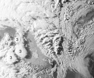
Matomas vaizdas
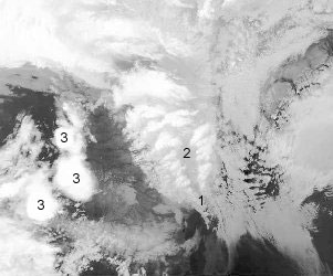
Infraraudonasis vaizdas
Pavyzdžiai: